The software module «Reservsion» is a tool for visualizing results of filtrational modeling in the software systems Tempest MORE, IRAP RMS and Eclipse.
The software module «Reservsion» is designed for solving the following problems:
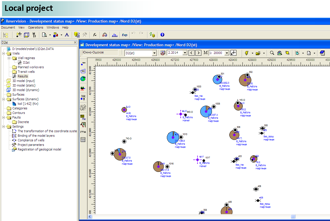
- Displaying the field of dynamic parameters resulting from filtrational modeling (oil saturation, pressure, etc.) and development parameters by wells. Fields and parameters are displaying by the number of standard documents of the software «BASPRO Optima»: maps, cubes, diagrams, charts and tables. It is possible to animate the information by times, and to estimate weighted average geological parameters and oil reserves;
- Preparation the geological and production basic data for the construction of filtrational model;
- Definition of the project wells and workovers for modeling in the software systems Tempest MORE, IRAP RMS and Eclipse;
- Editing the models, monitoring of the “adaptation” of the models to actual production parameters. The different formats of basic data can be used for the analysis of filtrational model.
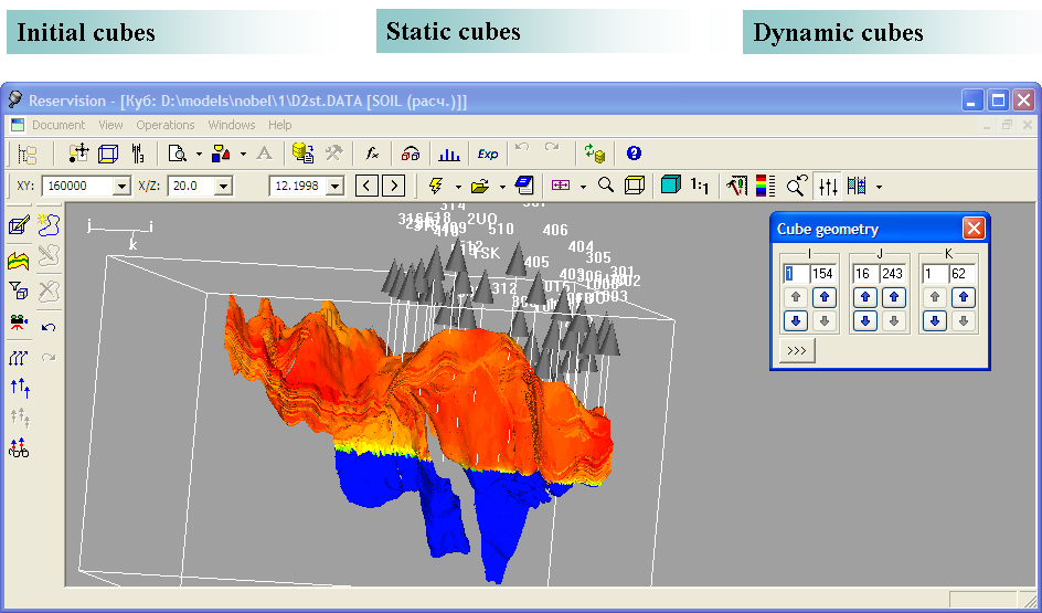
The user can rotate a cube, select some slices, perform some operations with them, create new arbitrary slices of a cube and animate dynamic parameters. It is also possible to create a display area of a cube, based on combinations of some parameters.
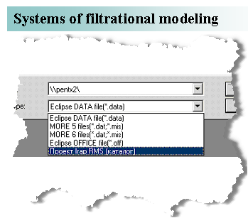
To visualize results, the software module «Reservsion» supports the following systems of filtrational modeling:
- ROXAR Tempest MORE
- Eclipse
- Irap RMS
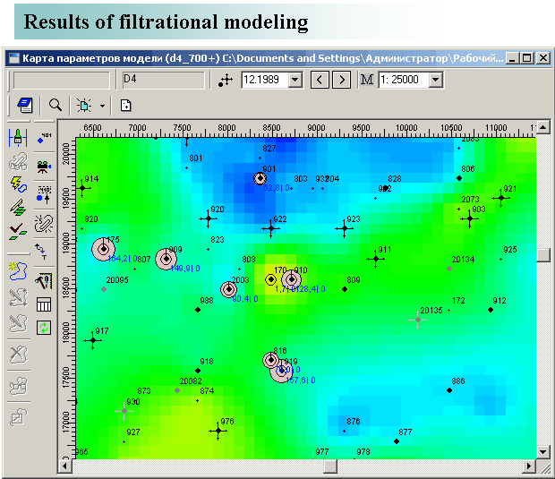
Results of filtrational modeling can contain:
- Static fields of parameters (sandiness, porosity, permeability)
- Dynamic (time-varying) fields of parameters (oil saturation, pressure)
- Basic fields (on the history of the field)
- Parameters of production/injection by wells (rates, water injectivity, water cut).
The software module «Reservsion» supports the features of different types of the documents, the working methods for solving the problems that arise from the analysis of development of oil and gas fields.
The main functions of the software module «Reservsion» are:
- Visualizations of the fields of properties of a geological environment within the boundaries of the formation (or the group of formations) in the form of a plurality of cells, forming a parallelepiped (cube);
- Visualizations of structural surfaces and two-dimensional fields of properties on map;
- Displaying slices and sections of a cube of properties;
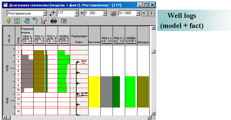
- Displaying the primary information used for the construction of a geological model: well logging, well logging interpretation results;
- Displaying model diagrams of properties used for the construction of a geological model;
- Editing values in some cells of a cube, which have been chosen by specific characteristic;
- Performing mathematical operations with a certain cube or with a group of cubes;
- Oil and gas reserves estimation;
- Transformation of a geological model to use it in a filtrational modeling «Upscaling»;
- Transformation from a geological model to a two-dimensional field of properties;
- Creating two-dimensional field of parameters (maps) based on three-dimensional geological and filtrational fields of parameters (cubes);
- Preparing data by wells for filtrational modeling (well regime, coordinates, perforation, etc.);
- Editing well parameters;
- Combined displaying and comparison of «Model - Fact» in all documents (tables, charts, diagrams, maps);
- Inaccuracy evaluation.
The software module «Reservsion» has an easy-to-use and intuitive interface of management, navigation and displaying information, and it uses conceptually new method of editing well parameters.
It is possible to visualize information in the form of tables, maps, well logs, correlation charts, maps and cubes.
To simplify the user work all the components of two-dimensional and three-dimensional models are stored in a hierarchical directory on the disk: in the local project or in the form of documents of the software «BASPRO Optima». In course of the works the local project is being built on the disk. It is a systematized collection of directories for storing files of the works results.
The software module «Explore» also has a system of communications and data exchange with MS Excel.
The software module «Reservsion» is designed to work with text documents and graphic images. It supports the following file formats: *.sf, *.ctr, *.ch, *.rel, *.txt, *.doc, *.las, *.xls, *.lst, *.cml, *.mdb, *.log, *.shp, *.bln, *.cps, *.csv, *.gen, *.bmp, *.jpg, *.gif, *.emf, *.png, *.tiff.
Basic data are reading from files of hydrodynamic model, that is created by the following systems of filtrational modeling: ROXAR Tempest MORE, IRAP RMS and Schlumberger Eclipse. Basic data can also be read from a corporate database (DBMS Oracle).
The functionality of the software module «Reservsion» allows the user to create the necessary output documents (maps, tables, correlation charts) in accordance with current industry standards.