The software module «Geomaster» is designed for solving the problems of a geological modeling: a selection of boundaries of geological objects, a visualization of geological bodies, a two-dimensional modeling of geological bodies and surfaces.
The fields of application are the problems of the selection of geological inhomogeneity items in the wells columns and the construction of geological models and oil deposits. In the software module «Geomaster» there are functions of uploading of geological objects boundaries into the database and calculation of estimates of petrophysical parameters over a range of object’s boundaries in order to construct two-dimensional model.
The user can perform operations both by separate wells and by groups of wells (correlation charts). With the function of the software module «Geomaster», the user can construct geological cross-sections, calculate, visualize and edit the two-dimensional fields of geological parameters and the surfaces of fluid contact.
The averaging results are used to construct maps of geological parameters and calculate of reserves. It is also possible to take into account a priori information and faults.
The main functions of the software module «Geomaster» are:
- Correlation of the boundaries of a geological object;
- Selection and editing of the boundaries of a geological object;
- Construction of two-dimensional fields of geological parameters;
- Geological two-dimensional modeling;
- Oil and gas reserves calculation;
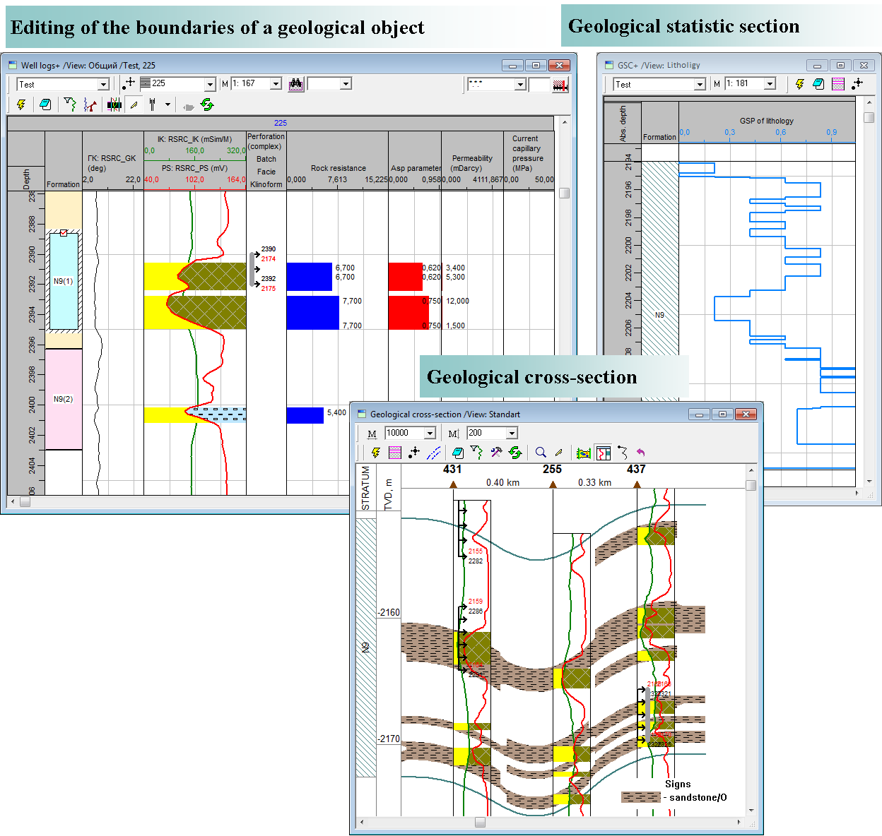
- Construction of geological cross-sections, well logs and correlation charts;
- Geostatistical data analysis;
- Core salvage binding and construction of petrophysical functions;
- Analysis and editing well logging interpretation results.
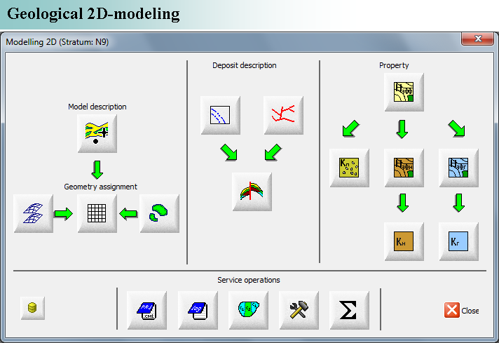
A feature of the software module «Geomaster» is a construction of a digital two-dimensional geological model. The digital two-dimensional geological model is a geological space as a set of two-dimensional cells with given properties. The process of construction of the digital two-dimensional geological model has successive nature of action. There are a number of steps that form oriented cycle:
- Configure basic parameters of the model;
- Selection of the wells used to construction of the model;
- Construction of the geometric skeleton of the model (geometric modeling);
- Selection of the contacts surfaces;
- Selection of the fault lines;
- Selection of the deposits (definition of its geometric boundaries);
- Construction of the field of an effective thickness;
- Construction of the field of a porosity;
- Construction of the field of an oil (gas) effective thickness;
- Construction of the field of an oil (gas) saturation factor.
It is possible to visualize information in the form of tables, well logs and correlation charts (with some more information: a perforation, well tests, boundaries, contacts, etc.).
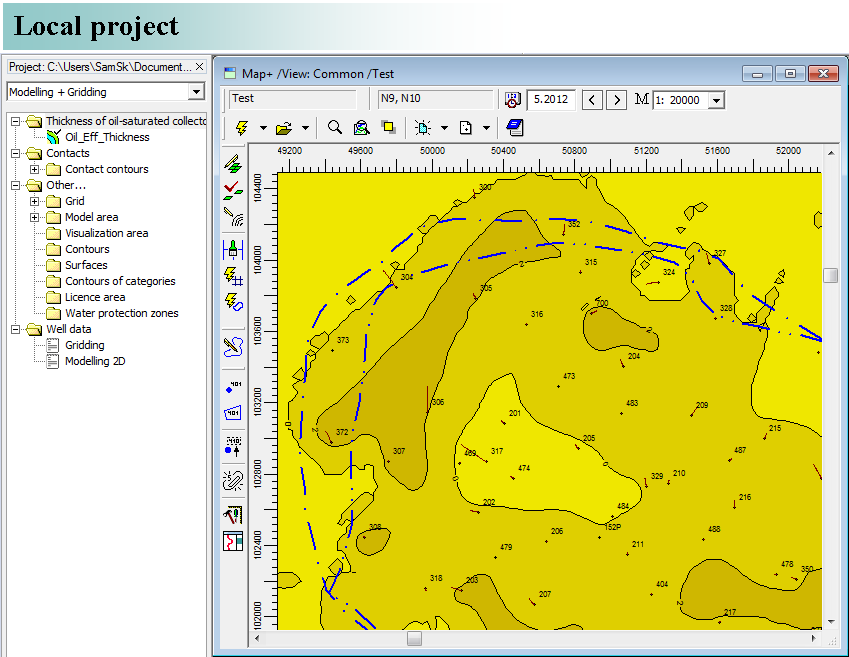
To simplify the user work all the components of two-dimensional models (maps, contours) are stored in a hierarchical directory on the disk: in the local project or in the form of documents of the software «BASPRO Optima». In course of the works the local project is being built on the disk. It is a systematized collection of directories for storing files of the works results (isobar maps, systems of contours, boundaries of development blocks, project wells, etc.). An author’s project, that has been created in the software module «Geomaster» and has got the status (for example, approved by the company), can be integrated into a corporate database for the general use.
Geological and geophysical data by wells used in the software module «Geomaster» can be represented by the following groups of parameters:
- Boundaries of geological objects;
- Properties of geological objects;
- Boundaries of fluid contacts;
- Well logging interpretation results;
- Well geometry and well position.
The above-mentioned parameters are the result of geological modeling and interpretation, so they have the characteristics such as the authorship and the status of their use. The authorship is expressed in the parameter «Work variants» in the data model. The status of their use is expressed in the parameter «Status» in the data model. Data models BDM Optima» and «BDM Project» support storage of work variants and statuses of geological data, and the software module «Geomaster» can use it for displaying and calculating.
Work variant in the corporate database
The classification of data by the work variant allows you to use data by wells relating to some geological, geophysical, production and research works.
Status of data in the corporate database
The classification of data by the status of data allows you to use data by wells having a different level of importance to the user. It is the alternative classification. In a database the parameter «Status» is expressed in a custom positive integer. The number zero means the corporate status of data. To receive data it is used by default.
Work variant in the local database
A field «Variant» is used for the classification of data by the work variant. In a local database the field «Variant» is expressed in a custom positive integer.
It is possible to vary the basic data in the local database (DBMS Access) and save the satisfactory results of calculation in main database (DBMS Oracle).
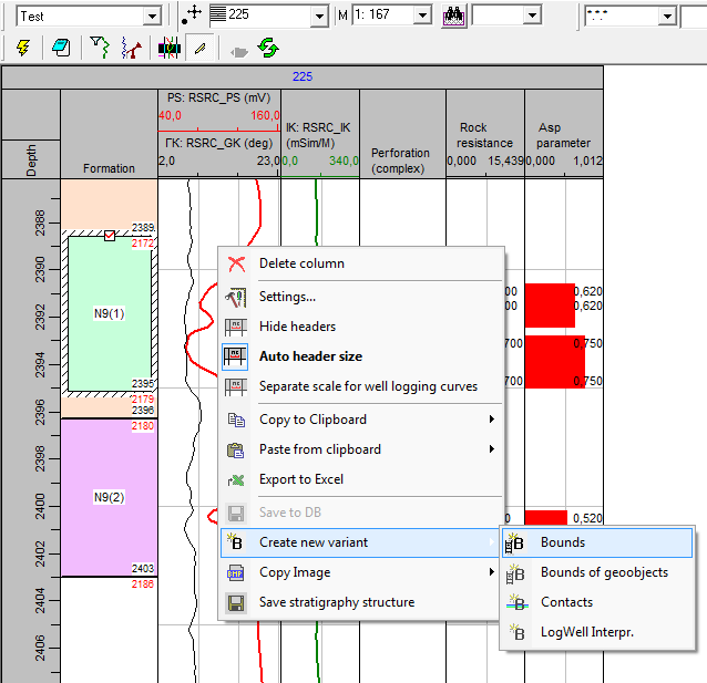
Documents «Well logs» and «Correlation chart» allow the user to perform a number of operations with the use of data by wells:
- Creating and editing boundaries;
- Creating and editing contacts;
- Calculating collector boundaries;
- Data smoothing;
- Core salvage binding;
- Data export and import;
- Definition of corrections to abs. depth.
The data sources for the software module «Geomaster» are:
- Data bank of local project (data model «BDM Project», DBMS Access);
- Corporate data bank (data model «BDM Optima», DBMS Oracle);
- Standard format data files, that are used to store contours, surfaces and scan-images;
- Special format data files, that are used to store system of contours, well parameters, system of project wells, planning workovers and documents of the software «BASPRO Optima».
The software « Geomaster » also has a system of communications and data exchange with MS Excel.
The software module «Explore» also has a system of communications and data exchange with MS Excel.
The software module «Geomaster» is designed to work with text documents and graphic images. It supports the following file formats: *.sf, *.ctr, *.ch, *.rel, *.txt, *.doc, *.las, *.xls, *.lst, *.cml, *.mdb, *.log, *.shp, *.bln, *.cps, *.csv, *.gen, *.bmp, *.jpg, *.gif, *.emf, *.png, *.tiff.
The functionality of the software module «Geomaster» allows the user to create the necessary output documents (maps, tables, correlation charts) in accordance with current industry standards.